Prepping for the Porkies

This week, my sister, Alison, and I are preparing to walk about 26 miles of some of the most beautiful and remote wilderness Michigan has to offer. We’re buying food and stuffing packs and gassing up cars.

Our path will take us up and down gentle mountains, along and across two rivers, past seven waterfalls, along the shore of the largest freshwater lake in the world, beneath old growth forests, and past abandoned copper mines. We will sleep the shortest nights of the year (just seven hours from twilight to twilight) to the sound of running water and waves and wind. We will be off the grid the entire time.

We will pay for this privilege with sore muscles and dirty hair.

Such a small price for utter bliss.


The Keweenaw Peninsula: Brockway Mountain Drive and Eagle River Falls

In the Western Upper Peninsula, the drive is kind of the point. There are no big cities, not many stores or restaurants or museums (though we’ll visit one museum on our way back through Houghton as we drive to the Porkies). What there is is scenery and lots of it.

If you’re up around Copper Harbor, I highly recommend that you take Brockway Mountain Drive on either your way there or back. Especially if you’re lucky enough to visit when the leaves are changing in late September.

We were there in June and it was marvelous even cloaked in unending green. In the photo below, the town of Copper Harbor is on the left and Lake Superior is shrouded in mist on what was a cold morning (for us trolls — people who live below the Mackinac Bridge — in June, anyway).

Zooming in a bit, we could pick out the dock from which the ferry left for Isle Royale earlier in the morning and, right next to it, our motel.

Don’t see it? It’s right here.

Further up the mountain, the views were spectacular.

At the top, there was a nice trio of signs that explained a bit of the history of the region.

Coming down from the mountain, the views are still lovely, and along M-26 you just might drive past a roadside waterfall or two. This is Jacob’s Falls, a sweet little cascade that goes right under the road and out the other side.

Here is a nine-year-old boy for scale.

What came as a lovely, almost ethereal surprise about five minutes down the road from Jacob’s Falls was this gorgeous scene on the Eagle River.

Someday I will attempt to paint this. The boy and I lingered long on the little historic Eagle River Bridge, staring at this magical scene. We’d been reading books in C. S. Lewis’s Chronicles of Narnia series and looking at this waterfall and the tapestry of trees around it made me feel like we were getting a glimpse into Aslan’s Country.

Reluctantly, we moved on, back toward the center of the Keweenaw Peninsula, back to Houghton to dip once more into our shared passion for geology as we explored the A. E. Seaman Mineral Museum on the campus of Michigan Tech University. But that’s a post for another day…

The Unsurpassed Beauty of Pictured Rocks National Lakeshore

You almost don’t need words with a landscape like this, but I’m going to provide some anyway so you know what you’re looking at.

Pictured Rocks National Lakeshore is on the south shore of Lake Superior between Munising and Grand Marais. And if you ever find yourself planning a trip to the UP, a Pictured Rocks Cruise or kayaking tour should be on your MUST DO list. There are only a couple features that are visible to the drive-in tourist, more for backpackers and hikers. But the most impressive features of this 43-mile long stretch of sandstone cliffs, arches, and caves cannot be seen unless you are out on the big lake.

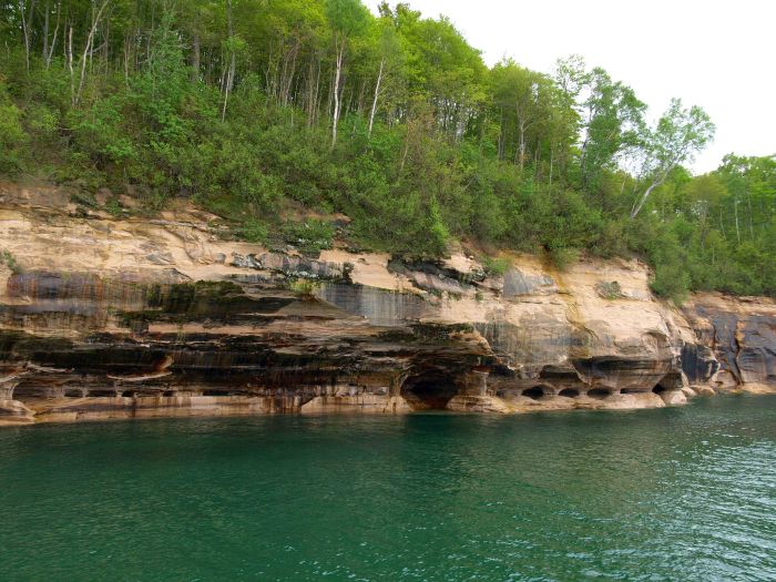
Battered by wind and waves, the shoreline varies between sheer cliffs, pockmarked with caves, and idyllic sandy beaches and inviting waterfalls. And every so often, a “picture” in the rocks–a structure or illusion that suggests an object, like finding shapes in the clouds. One of these is Miner’s Castle (below) which you can drive to easily but which, in my mind, is far from the most impressive or exciting.

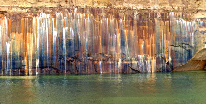
In addition to the “pictures” (which we’ll see a lot more of below) the cliffs are “painted” by minerals dissolved by underground springs and streams of water that then drip down the sides of the sandstone. The color indicates the mineral: white is calcite, orange is iron, gray is dolomite, blues and greens are copper, black is manganese.

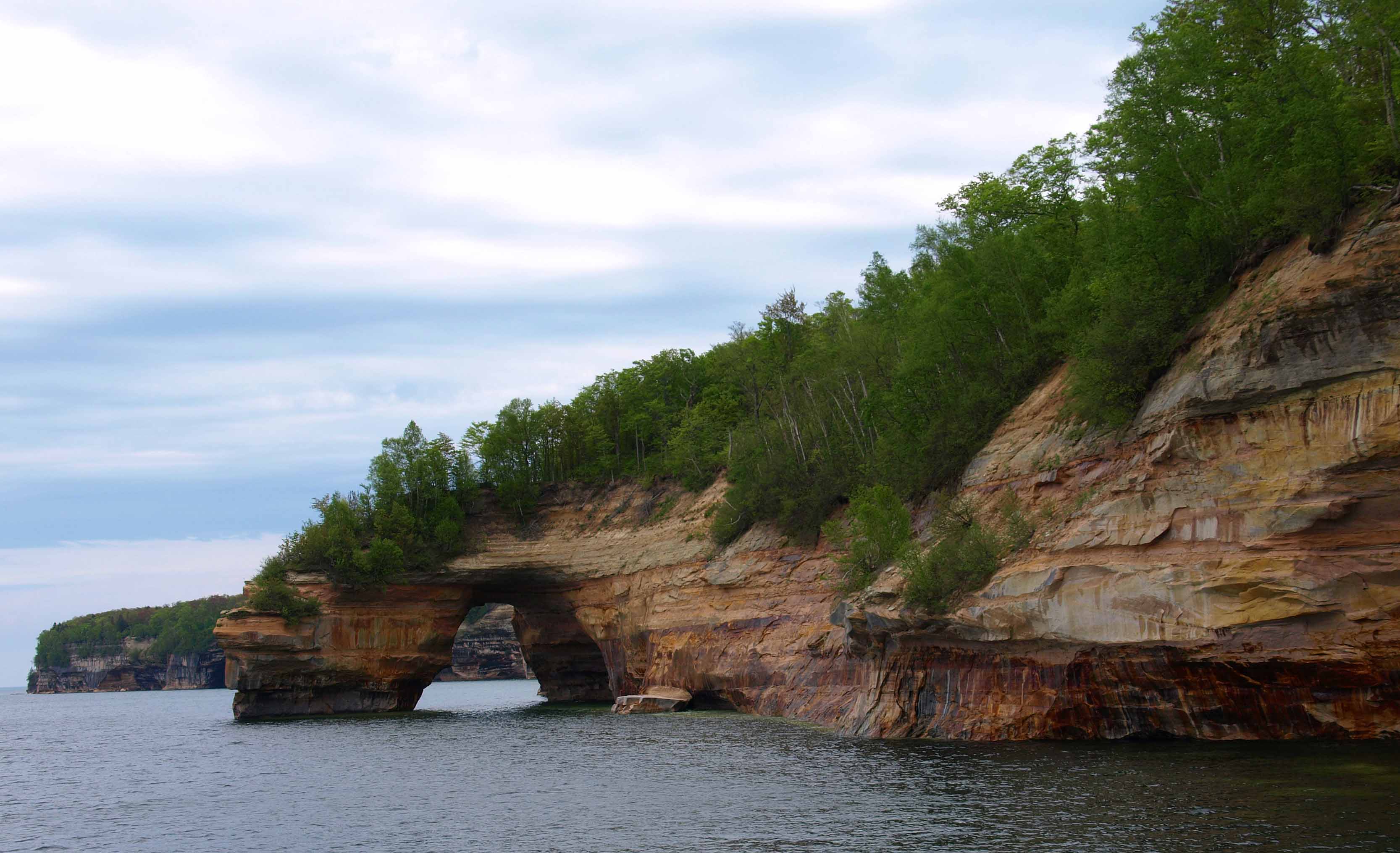
The various points have colorful names, such as the arch below, which is called Lover’s Leap. Our guide on the cruise reminded us that it was not such a great name because if you take a flying leap into the lake from this point it is into only about four feet of water. So maybe this is for jilted and suicidal lovers only…

Things can change quickly though. Our guide pointed out a sandbar to us, saying, “If you were to stand on that sandbar where you see the water looks more brown, you would be in water up to about your waist. One step closer to the boat where we are now and you’d be in 65 feet of water.” Superior is beautiful, yes, but dangerous when you don’t know what you’re doing.

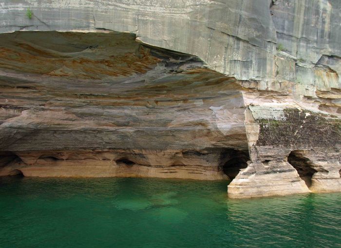
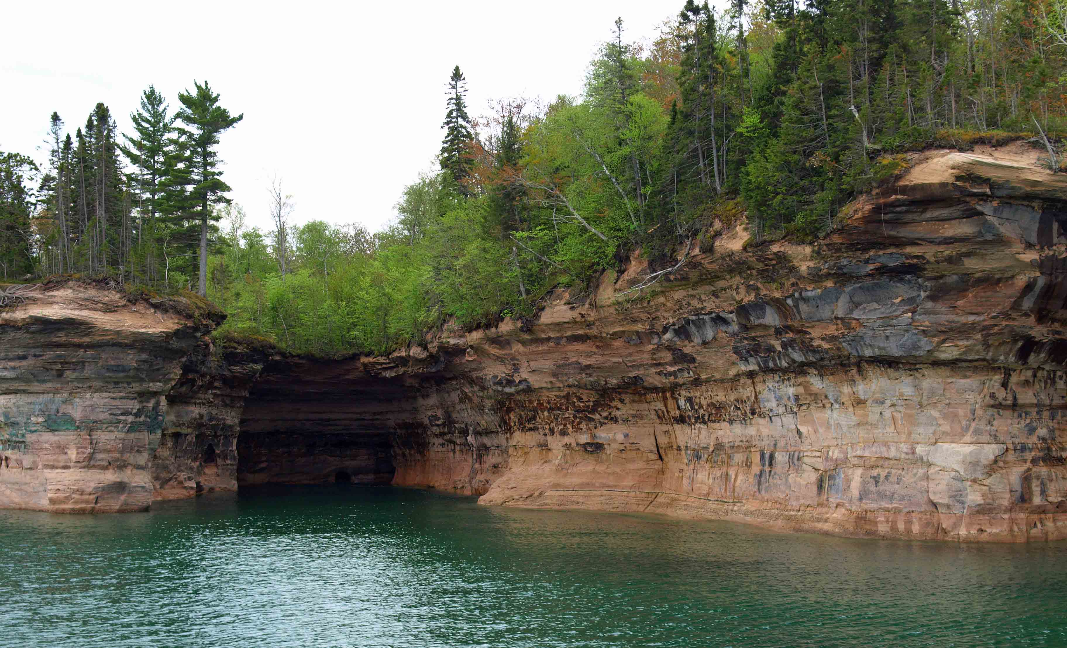
Probably not all of the caves on the lakeshore have names, but this one does — Rainbow Cave, for the streaks of minerals on the walls and the turquoise water.

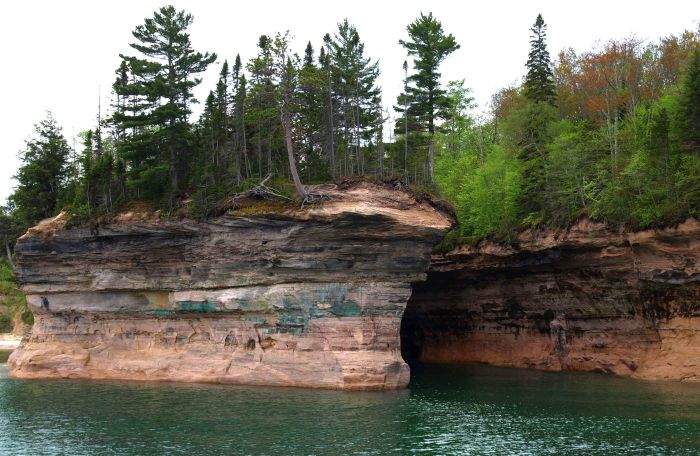
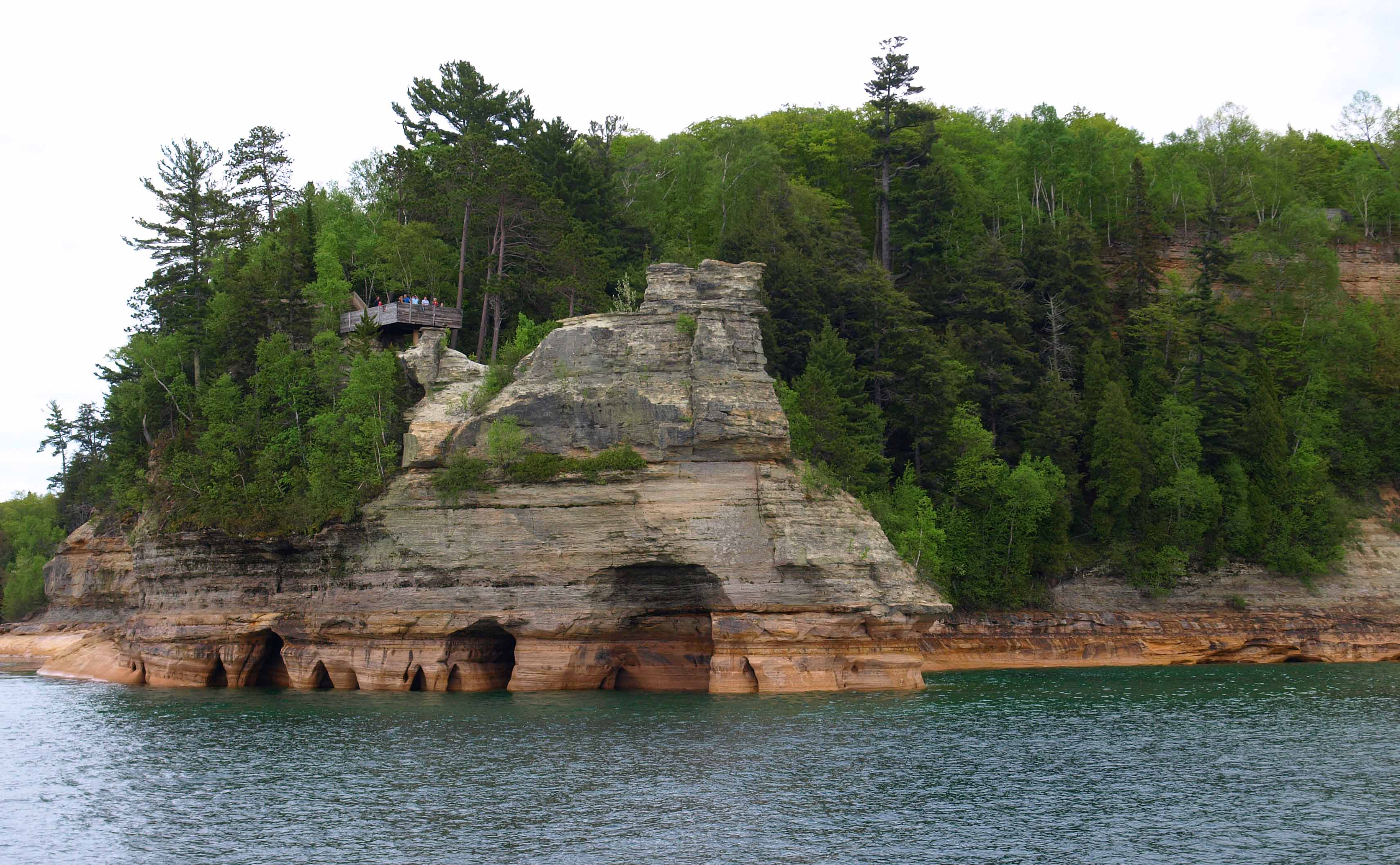
When I took this cruise as a child, this point of land was called Indian Head. Our guide this time around was careful to be PC about it, but its name is certainly no insult. The Native Americans who fished these waters called this rock the Gitchee Manitou, or Great Spirit. They saw themselves in its strong jaw and nose, its sloping brow, and its steadfastness in the storm.

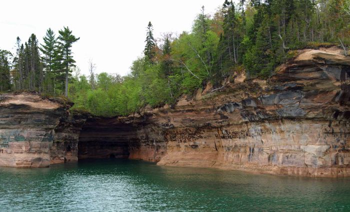
Someday I intend to kayak Pictured Rocks, if only so I can slip into places like this to see how far back those caves go…

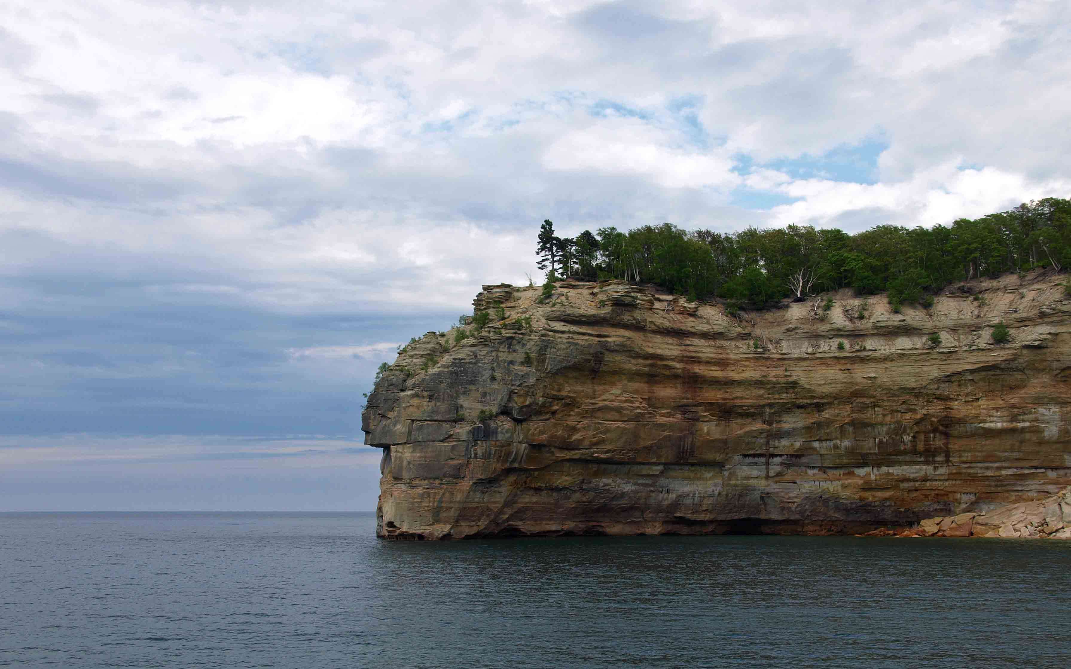
Sometimes a single cliff or point is not enough to make a picture, but a series of them is. This is Battleship Row, where five or six points of land at the right angle look like a fleet lined up at port.

The winters are long in the UP and the gales off of this inland sea are powerful enough to sink freighters, as any Gordon Lightfoot fan knows. So I always like to see trees that hang on despite adversity, like this pine gripping the side of this cliff.

Can you see the goblet or vase in the rocks below?


How about a set of sturdy bear or elephant legs?

A pirate’s face below a gray tricorn hat? (Barring that, you might at least see a set of very round eyes and a rabbit-like nose perhaps?)

This tight cove is Chapel Cove, and the interesting thing here is better viewed in the second picture.

This is the spot with the most copper coming through, as you can see by the deep teal about halfway up the rocks.

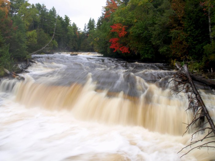
Just beyond Chapel Cove is Chapel Beach and Chapel Falls, both accessible by car and a short walk.

And then the feature which is almost everyone’s favorite: Chapel Rock.

It may not be wholly obvious from that first picture that there is indeed a white pine tree (our state tree) atop the rock. And even if you caught that right away, it may be tough to tell just how it can live on a rock that is almost completely separated from the mainland. The photo below reveals the mystery.

A thick tangle of roots, which had developed at a time when Chapel Rock was still an arch and connected to the rest of the forest, is that tree’s main source of water and nutrients from the soil. Tenacity. You need it to live in such an unforgiving place. Incidentally, in what can be a very difficult and sometimes treacherous trail that forces the hiker to the very edge of unstable cliffs in this stretch of the North Country Trail, the only fences the National Park Service has constructed are those protecting this feature (and Miner’s Castle) from people who might otherwise trample and climb and damage it.

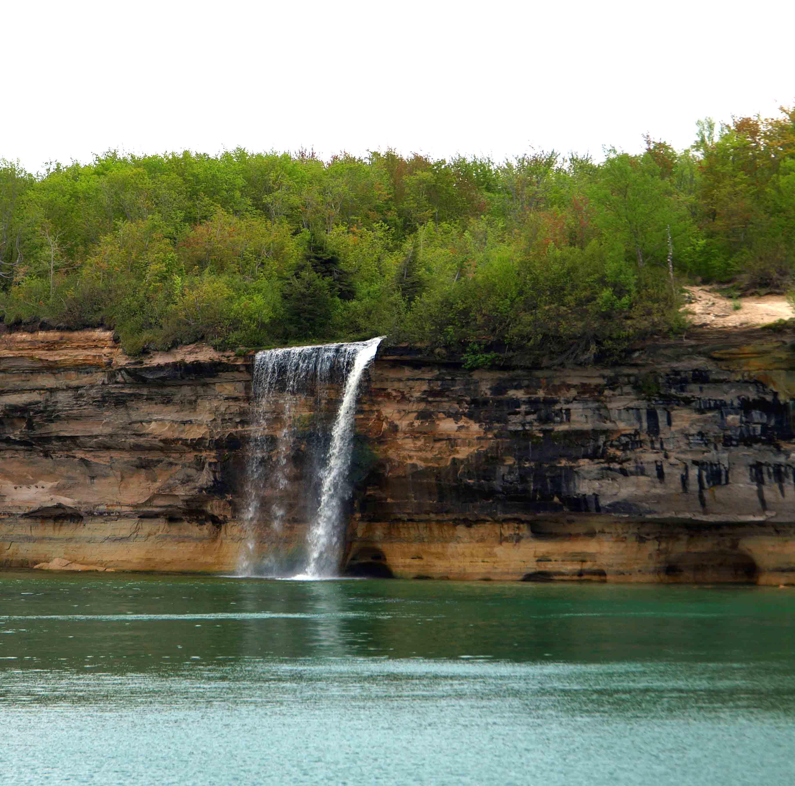
If you take the longer cruise option, you will get to see Spray Falls, which empties into Lake Superior and can only be seen from the water. In late summer during a dry year, this waterfall may not be flowing at all, so go in June.


Another waterfall you can appreciate from the lake is the lovely Bridal Veil Falls…

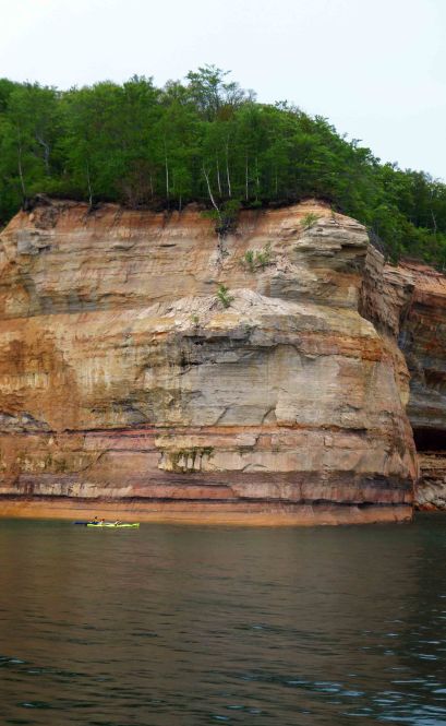
And just in case the scale of these features has eluded you…see those kayakers?

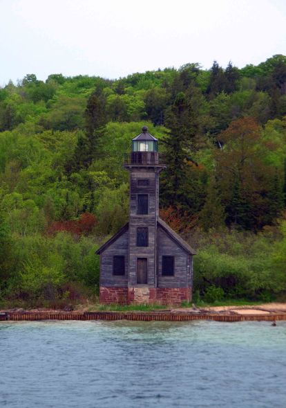
On the way back to port the boat swung by Grand Island and the East Channel Lighthouse, which opened for service in 1868.

The island is used largely by sportsmen, tourists, and hikers, but there are a few houses on it. The summer residents of these houses have no plumbing and no electricity, and they are the keepers and restorers of the lighthouse, which hasn’t been in service since 1913.

For days when I asked my son what his favorite part of the trip so far had been, he’d say it was the Pictured Rocks Cruise. His answer would change later, but that is another post for another day…

Just trust me and put this on your bucket list.

My Second Oil Painting: A Sepia-Toned Waterfall

This evening I executed my second oil painting.

I’m largely happy with it, though next time I do a shape with contact paper I will get some that is a bit stronger as a few little gaps let out some paint and I had to take it off the canvas as best I could with paint thinner. And once I’m at the stage where I think I’m getting good enough to give anything away, I’ll have to get some professional grade canvases because, as you can see, this one was not stretched tight enough.

For this painting I followed one of Bob Ross’s videos, one I got on DVD for my birthday. It started with contact paper and black gesso (which is an acrylic paint and allowed to dry completely.

Next you cover the whole canvas with a very thin coat of liquid clear, followed up by a thin coat of a brown color created from equal parts alizarin crimson and sap green.

And after this point I totally forgot to stop between each stage to take pictures! But you start from what is in the very background in your mind and work forward, each layer of tree shapes getting darker and darker as they get closer to you. Add the waterfall, a cliff face, and water at the bottom, plus some highlights and water lines and you’re nearly done.

Then you get to take that ugly contact paper off.

I definitely made some mistakes in this one, and it’s harder than it looks when Bob does it to make tree trunks and branches that look decent (more practice with the liner brush is needed). But it’s also a lot easier than you think it will be, especially if you already have some experience with a brush.

I hope to do a new painting every Sunday, so you’re likely to see more of these soon. I hope you like seeing them, and seriously, it’s less complicated than you think. If you can make the investment (getting started can be pricey) you can absolutely have some fun painting in oils.

Unintentional Water Features at Tahquamenon Falls

Remember way back when wetlands were just called swamps? Someone in the 1970s or 1980s apparently endeavored to put a more positive spin on these soggy topographical features. Wetland sounds so much more pleasant than swamp, after all.

OLYMPUS DIGITAL CAMERA

Well, if you hike north from the Upper Falls at Tahquamenon along the Giant Pines Trail Loop and the Wilderness Trail Loop, you will find yourself in a landscape that tends strongly toward swamp. Remember the soggy areas Alison and I encountered on the trail between the Lower and Upper Falls? Multiply that by, oh, let’s say 500–or 50, I don’t know. But whatever the correct number, if you plan to hike this section prepare to get your feet wet. Also, unless the DNR or whoever gets out there with a chainsaw soon, prepare to duck under and crawl over many, many trees.

Despite some sludgy trail conditions, there were some nice surprises early on, like this enormous, 185-year-old white pine tree, which was approximately 120 feet tall, 5 feet in diameter, and has a circumference of nearly 16 feet.

OLYMPUS DIGITAL CAMERAMy sister looked pretty small next to it.

OLYMPUS DIGITAL CAMERA

Not far from this mammoth lifeform we found this fat little caterpillar, which I think will be a Luna Moth when it’s all grown up.

OLYMPUS DIGITAL CAMERA

But not too far into our second hike of the first day, the surprises turned simultaneously more unpleasant and more impressive.

Alison and I first noticed a tree across our path that had obviously been cut down by a beaver–its distinctive teeth marks cluing us in. A moment later we realized that we were walking alongside a lake. And that the water level was a foot or so higher than the soggy ground upon which we were treading.

OLYMPUS DIGITAL CAMERA

Yes, we were at the edge of a beaver’s carefully constructed dam.

OLYMPUS DIGITAL CAMERA

And, as I said, we were alternately amazed and irritated. The amazement is obvious. Beavers are incredible creatures with incredible talents. The beaver here had created his own perfect environment. That first photo in this post was of the beautiful wetland home he had made possible by building this:

OLYMPUS DIGITAL CAMERA

He built it not across a rushing river but along the outskirts of the slowly moving water of some sluggish swamp, and we were on the very edge of it. It’s an enchanting position to be in.

The irritation may not be so obvious from these photos. But this next one may give you a hint:

OLYMPUS DIGITAL CAMERA

You see that slim tree with the blue painted blaze? That, my friend, is the indicator of the North Country Trail. And, as I’m sure you noticed, it’s been incorporated into this beaver’s swimming pool. In fact, the beaver had obliterated much of the trail. I don’t know if he just made this dam this summer or if it really has been a long time since anyone at Tahquamenon Falls State Park has bothered to groom their backcountry trails (I kind of suspect the latter, frankly). Either way, it was slow, wet going here. It was swamp here.

At one point we realized that the only semi-dry option to move forward was to walk along the top of the dam itself as we tried to get back on the trail. We stepped gingerly, grasping at branches the beaver had as yet left untouched, leaned away from the water, and prayed that he was a good builder who didn’t cut corners.

We did make it past the wetland eventually, but with very wet shoes and socks and more than a few near-misses. As evening approached and the gray skies above rumbled a warning of the storms we knew were supposed to come that night, we tried to make up time as we rushed toward the Wilderness Campsite. We got the tent up before dark, ate a late supper, and used the surprisingly unsmelly and amusingly exhibitionist toilet.

OLYMPUS DIGITAL CAMERA

It made me think of this iconic moment from Scrubs:

ScrubsRoofToilet
Yes, that’s Michael J. Fox’s Dr. Kevin Casey finally overcoming his OCD in order to sit on the roof toilet.

We bedded down for some much needed sleep as the forest darkened swiftly around us and flashes of lightning occasionally lit up the tent. As we fell asleep that night, or else as we woke the next morning, it’s hard to recall, we heard the strangest bird call, like a cartoon siren that ended with a honk. Or like a loon on steroids. It sounded like it had to come from a very large bird. After listening to some calls, I think it is quite possible it was a sandhill crane. Go to about the 1:50 mark on this video and you’ll hear just about what I think we heard:

In the morning I remembered to get a photo of our campsite before we packed back up to face yet more trail challenges and more rain on the way to our next campsite.

OLYMPUS DIGITAL CAMERA

We were surrounded by utter silence, complete solitude, and zillions of wild blueberries (the presence of which during our entire hike had me ultra aware of the possibility of encountering black bears fattening up for winter).

It was beautiful.

Hiking the Trail between Lower and Upper Tahquamenon Falls

Alison and I headed off down the trail between the Lower and Upper Falls after a dire warning regarding “muckiness” from a few “helpful” folks. (People at the Lower Falls were super talkative and quite bemused by seeing two people with packs on their backs–“Hey girls, lookin’ for your campsite?”)
OLYMPUS DIGITAL CAMERA

The trail started off dry and strewn with roots but very lovely. It quickly became both wet and root-strewn, but the roots were quite helpful as places to step to avoid the suction of the wet earth. We had such a snowy winter and a rainy spring and summer, that it makes me think that if you went in a drier year you wouldn’t have to deal with quite as much muck.

OLYMPUS DIGITAL CAMERA

Soon it got pretty sloppy indeed, with an occasional branch tossed on the trail to use as a “bridge.”

OLYMPUS DIGITAL CAMERA

Alison and I did a LOT of balancing during this entire trip, which is a little tricky with a pack throwing off your center of gravity.

OLYMPUS DIGITAL CAMERA

It was decided that we both could have benefited from a good walking stick, as saplings and tree branches were not always handy to aid our trek across these boggy spots. (Little did we know, we had much MUCH soggier challenges ahead of us.)

Along the way we saw several intrepid trees with roots stretching over rocks to reach the soil below.

OLYMPUS DIGITAL CAMERA

OLYMPUS DIGITAL CAMERA

OLYMPUS DIGITAL CAMERAWe found an enchanting miniature “falls” that I wish I had in my backyard.

OLYMPUS DIGITAL CAMERA

To our left, the “rushing Taquamenaw” rolled on over resistant rocks, creating many spots of pleasant-sounding rapids.

OLYMPUS DIGITAL CAMERA

But other areas were wide and deep and calm.

OLYMPUS DIGITAL CAMERA

In spots you could really see just how like a cup of tea the water really is.

OLYMPUS DIGITAL CAMERA

We did take the time to notice the little things: many different types of mosses, gray-green lichens, TONS of mushrooms of every shape and color…

OLYMPUS DIGITAL CAMERA

…a long-dead tree that had broken down to the point that it resembled the layers of rocks you can see in this area of the Upper Peninsula…

OLYMPUS DIGITAL CAMERA

…and exciting hints of color that pointed us to the coming autumn season.

OLYMPUS DIGITAL CAMERA

We did run into the occasional tree down on the trail (again, a warning sign of things to come) but managed to navigate them fairly easily on this portion of the trail.

OLYMPUS DIGITAL CAMERA

And despite the fact that while planning this trip I was under the mistaken impression that the distance between the Lower and Upper Falls was actually two miles rather than four miles (I can haz math?) we did reach the Upper Falls after a time.

OLYMPUS DIGITAL CAMERA

Photos of the beautiful Upper Falls will be in the next post, but here’s a little taste of what greeted us when we emerged from the trail in the late afternoon.

OLYMPUS DIGITAL CAMERA

The Lower Falls at Tahquamenon Falls State Park

OLYMPUS DIGITAL CAMERA

Alison and I began our hike this year at the Lower Falls at Tahquamenon Falls State Park near Paradise, Michigan. The last time I was at the falls was 2009 when I brought my then one-year-old son for a quick day trip when we were in the Soo.

TahquamenonWithCalvin copy

The last time Alison was there was back in the mid 1980s when our family “did the UP.” All she remembered about that trip was how embarrassed our parents were when she pointed at a group of Amish people and loudly asked, “Why are they dressed like that?”

Back in the 1980s, there were apparently no railings by the Lower Falls. I'm pretty sure they frown on you standing on this slippery rock nowadays.
Back in the 1980s, there were apparently no railings by the Lower Falls. I’m pretty sure they frown on you standing on this slippery rock nowadays. Alison is on the left. I’m on the right. That woman holding onto us for dear life is our mother.

This time around, nearly thirty years later (THIRTY YEARS!) she did not point at anyone or judge their attire.

OLYMPUS DIGITAL CAMERA

Anyway, what was I saying? Oh, yes. We began our hike at the Lower Falls.

OLYMPUS DIGITAL CAMERA
Note the “Danger; stay within fence” sign that now keeps people off the very rock upon which we were so blithely perched back in 1985.

People always say to visit the Lower Falls first, as they are less impressive than the nearly 50-foot drop of the Upper Falls. But for my money, the Lower Falls are the prettier of the two.

OLYMPUS DIGITAL CAMERA

We also ended our trip at the Lower Falls two days later, and even in those two days the trees showed more color. I imagine that within the next week or two it will be absolutely breathtaking up there.

OLYMPUS DIGITAL CAMERA

The Lower Falls are actually made up of four or five (or perhaps more) small drops in three separate areas that all empty out into a pleasant looking pool before moving on down the line to Lake Superior.

OLYMPUS DIGITAL CAMERA

The water of the Tahquamenon River is stained brown from the tannins leeched by the nearby cedar swamps (more–oh, so much more–on swamps in a later post). Even water filtered from nearby Clark Lake (again, more in a later post) is a bit on the brown side.

OLYMPUS DIGITAL CAMERAAfter we had our fill of the Lower Falls on Friday, we headed for the Upper Falls via the trail. And that is where our adventure really begins…

OLYMPUS DIGITAL CAMERA
I believe you mean “primitive” trail, Department of Natural Resources.

On My Way to Parts North…

UpperFalls10 copyWe’ve hiked Pictured Rocks and Grand Sable Dunes. This year my sister Alison and I are headed up to Tahquamenon Falls, the land of Longfellow’s Hiawatha.

“Lay aside your cloak, O Birch-tree!
Lay aside your white-skin wrapper,
For the Summer-time is coming,
And the sun is warm in heaven,
And you need no white-skin wrapper!”
Thus aloud cried Hiawatha
In the solitary forest,
By the rushing Taquamenaw,
When the birds were singing gayly,
In the Moon of Leaves were singing,
And the sun, from sleep awaking,
Started up and said, “Behold me!
Gheezis, the great Sun, behold me!”
And the tree with all its branches
Rustled in the breeze of morning,
Saying, with a sigh of patience,
“Take my cloak, O Hiawatha!”

I was beyond thrilled to see many maple trees already turning red and orange on my drive to Grand Rapids this morning, and I am hoping for at least a touch of color way up near the fabled shores of Gitche Gumee (that’s Lake Superior, in case you were unaware).

I can’t wait to get there and I can’t wait to share pictures with all of you.